

 Comments (
 Printable Version
 Email This
 Font
FontThe most comprehensive map ever put together detailing the spread of the pathogen known as sudden oak death shows the tree-killing microbe moving down from the forested hills into residential areas all over the Bay Area.
The new map, called SODMAP, was inspired by the volunteer mapping programs by UC Berkeley's Forest Pathology and Mycology Laboratory and is designed to help cities and counties plan projects and allow citizens to protect historic heritage trees.
It plots the results of every test recorded by researchers at UC Berkeley and UC Davis, the California Department of Forestry and Fire Protection, the Department of Food and Agriculture, and thousands of citizen volunteers.
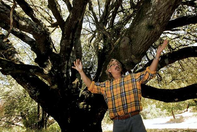
"No other forest disease has such a complete distribution map," said Matteo Garbelotto, a UC Berkeley forest pathologist who runs the lab and helped create the map. "Sudden oak death, as an infectious disease, just moves through the landscape, so sharing information is really essential to understand how the disease is distributed."
The Google Earth map is being released Thursday in coordination with an international symposium on sudden oak death being held in Petaluma. It is the latest effort to involve residents in the battle against the mysterious pathogen, which has killed hundreds of thousands of oak trees from Big Sur to southern Oregon.
The plan is to update the map every year and track the movement of the disease through neighborhoods and counties. The idea is for residents and city and county officials to look at the map and determine where diseased trees are located so they can protect healthy ones and, perhaps, delay landscaping and other microbe-stirring work until the dry season.
Sudden oak death has proved to be most virulent during rainy months. Trees within a kilometer, or about six-tenths of a mile, of a diseased tree are considered to be at high risk of becoming infected, particularly during wet winters.
"Let's say your property is 1 mile from a tree that is infected. That would mean you don't have to worry now," Garbelotto said.
"Oaks are usually infected only when bay trees or tan oaks are really close, so basically if the front of the disease is more than 0.6 miles away it is impossible for your oak to become infected. Your property could nevertheless be within 0.6 miles next year or maybe in 10 years. This map allows people to decide in real time whether they need to take action."
Discovered in 1995
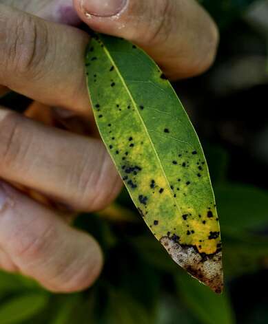
Sudden oak death, discovered in Mill Valley in 1995, exists in forests and wildlands in 14 California counties and in Curry County, Ore. It kills big oak trees and the smaller, understory tan oaks, which have been nearly wiped out in portions of Big Sur, Jack London State Park in Sonoma County, China Camp State Park in Marin County and the Marin Municipal Water District watershed lands near Mount Tamalpais.
The disease, known scientifically as Phytophthora ramorum, has 107 susceptible host plants. Infected California bay laurels are the most effective spreaders of the deadly microbe, but such common garden ornamentals as camellias and rhododendrons can also spread the tree-strangling pathogen to oaks.
Arborists and ecologists are afraid sudden oak death could eventually denude California's golden hills of its signature tree. As it is, experts predict as many as 90 percent of California's live oaks and black oaks could die from the disease within 25 years.
Spreads via water
The pathogen is known to spread in water and has been detected in numerous waterways, including the Crystal Springs Reservoir. Heavy rains in 2010 and 2011 are believed to have caused a spike in infections.
New infestations were found last year in urban and suburban areas of Napa, Berkeley and other locations in southern Alameda County. The largest new infestation was along South Skyline Boulevard, west of Saratoga and Los Gatos, where 97 percent of the specimens that were collected tested positive for the pathogen.
The new map, which does not include infections in nurseries, shows the continued spread of the microbe into populated areas in the Napa and Sonoma valleys and down from the East Bay hills westward into the Claremont and Montclair areas of north Berkeley and Oakland.
The disease is also moving south and east from the top of the coast range on the Peninsula into Woodside, Los Altos Hills and Atherton. It is creeping eastward from the Santa Cruz Mountains into the Carmel Valley.
"We're seeing it in areas where we didn't have it before that are more residential," Garbelotto said.
Mysteries remain
The map shows that damp, foggy coastal areas are most at risk, Garbelotto said, but the microbe spreads just as fast inland during wet years.
The pathogen's movements, however, are still mysterious even after years of study. Nobody knows, for instance, how the disease made the jump to Humboldt County, where it is now poised on the edge of Redwood National and State Parks. Researchers also haven't figured out how it got to MacKerricher State Park, near Fort Bragg. The nearest infection is 30 miles to the south.
There are still no infections in Del Norte or San Luis Obispo counties, or anywhere in the Sierra Nevada mountains.
"People need to know that if they can take action before their trees are infected, then they can really slow down the rate of infection and minimize the number of trees that are infected," Garbelotto said. "The biggest hindrance to protecting oaks is that people don't think about it until the trees are infected, so the more we let people know there are these tools, the more they will know they can do things to make things better."
Killer Oak map
The SODMAP and other information on sudden oak death can be found at: links.sfgate.com/ZLLD and links.sfgate.com/ZLLE
How you can help
-- Remove California bay laurel trees that are near oaks. This increases the survival rate of oaks tenfold.
-- Use phosphonate spray, which has proved to be effective against the disease.
-- Avoid large-scale projects such as grading, soil removal or tree pruning in infected areas during the rainy season.
Peter Fimrite is a San Francisco Chronicle staff writer. E-mail: pfimrite@sfchronicle.com Twitter: @pfimrite
 Email This