1.1 Remote Sensing
Remote sensing is a technology used for obtaining information about a target through the analysis of data acquired from the target at a distance. It is composed of three parts, the targets - objects or phenomena in an area; the data acquisition - through certain instruments; and the data analysis - again by some devices. This definition is so broad that the vision system of human eyes, sonar sounding of the sea floor, ultrasound and x-rays used in medical sciences, laser probing of atmospheric particles, are all included. The target can be as big as the earth, the moon and other planets, or as small as biological cells that can only be seen through microscopes. A diagrammatic illustration of the remote sensing process is shown in Figure 1.1.
An essential component in geomatics, natural resource and environmental studies is the measurement and mapping of the earth surface - land and water bodies. We are interested in knowing the types of objects, the quality and quantity of various objects, their distribution in space and time, their spatial and temporal relationships, etc. In this book, we introduce some of the major remote sensing systems used for mapping the earth. We concentrate on examining how satellite and airborne images about the earth are collected, processed and analyzed. We illustrate various remote sensing techniques for information extraction about the identity, quantity, spatial and temporal distribution of various targets of interest.
Remote sensing data acquisition can be conducted on such platforms as aircraft, satellites, balloons, rockets, space shuttles, etc. Inside or on-board these platforms, we use sensors to collect data. Sensors include aerial photographic cameras and non-photographic instruments, such as radiometers, electro-optical scanners, radar systems, etc. The platform and sensors will be discussed in detail later.
Electro-magnetic energy is reflected, transmitted or emitted by the target and recorded by the sensor. Because energy travels through the medium of the earth's atmosphere, it is modified such that the signal between the target and the sensor will differ. The effects of the atmosphere on remote sensing will be examined later. Methods will be introduced to reduce such atmospheric effects.
Once image data are acquired, we need methods for interpreting and analyzing images. By knowing "what" information we expect to derive from remote sensing, we will examine methods that can be used to obtain the desirable information. We are interested in "how" various methods of remote sensing data analysis can be used.
In summary, we want to know how electromagnetic energy is recorded as remotely sensed data, and how such data are transformed into valuable information about the earth surface.
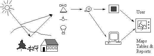
Figure 1.1 The Flows of Energy and Information in Remote Sensing
![]()
![]()
![]()
![]()
![]()
![]()
![]()
![]()
![]()
![]()
![]()
![]()
![]()
![]()