We begin to ask: what are the factors that make remotely sensed images taken for the same target different? Remotely sensed data record the dynamics of the earth surface. The three-dimensional earth surface is changing as time goes. Two images taken at the same place with the same imaging condition will not be the same if they are obtained at different times. Among many other factors that will be introduced in later chapters, sensor and platform design affect the quality of remotely sensed data.
Remote sensing data can be considered as models of the earth surface at very low level of generalization. Among various factors that affect the quality and information content of remotely sensed data, two concepts are extremely important for us to understand. They determine the level of details of the modeling process. These are the resolution and the sampling frequency.
Resolution the maximum separating or discriminating power of a measurement. It can be divided into four types: spectral, radiometric, spatial and temporal. Sampling frequency determines how frequent are data collected. There are three types of sampling important to remote sensing: spectral, spatial and temporal. Combinations of resolutions and sampling frequencies have made it possible for us to have different types of remote sensing data.
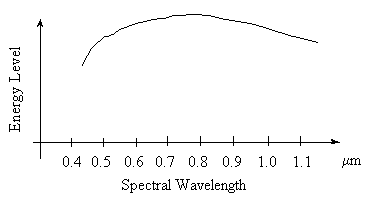
For example, assume that the level of solar energy coming from the sun and passing through the atmosphere at a spectral region between 0.4 mm - 1.1 mm is distributed as in Fig. 1.2. This is a continuous curve.
Fig. 1.2 Solar Energy Reaching the Earth Surface
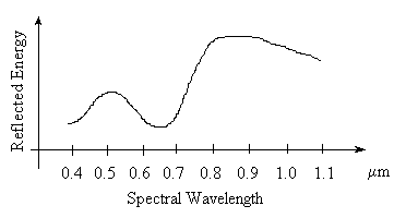
After the solar energy interacts with a target such as a forest on the earth, the energy is partly absorbed, transmitted, or scattered and reflected. Assume that the level of the scattered and reflected energy collected by a sensor behaves in a manner as illustrated in Fig. 1.3.
Fig. 1.3 Reflected Solar Energy by TreesThe process that makes the shape of the energy curve change from Fig. 1.2 change to Fig. 1.3 will be discussed later. Let us use Fig. 1.3 to discuss the concepts of spectral resolution and spectral sampling.
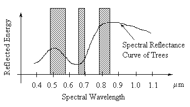
Fig. 1.4 Example of Differences in Spectral Resolution and Spectral Sampling
In Figure 1.4, the three shaded bars A, B, and C represent three spectral bands. The width of each bar covers a spectral range within which no signal variation can be resolved. The width of each spectral band represents its spectral resolution. The resolution of A is coarser than the resolution of B. This is because spectral details within band A that cannot be discriminated may be partly discriminated with a spectral resolution as narrow as band B. The resolution relationships among the three bands are:Resolution of A < Resolution of C < Resolution of B
Sampling determines the various ways we use to record a spectral curve. If data storage is not an issue, we may choose to sample the entire spectral curve with many narrow spectral bands. Sometimes, we choose to make a discrete sampling over a spectral curve (Figure 1.4). The questions are: which way of sampling is more appropriate and what resolution is better? It is obvious that if we use a low resolution, we are going to blur the curve. The finer the resolution is, the more precise can we restore a curve, provided that sufficient spectral sampling frequency is used.
The difference between imaging spectrometers and earlier generation sensors is in the difference of the spectral sampling frequency. Sensors of earlier generations use selective spectral sampling. Imaging spectrometers have a complete systematic sampling scheme over the entire spectral range. An imaging spectrometer, such as CASI, has 288 spectral bands between 0.43 - 0.92 spectral region, while earlier generation sensors only have 3 - 7 spectral bands.
Spatial resolution and sampling
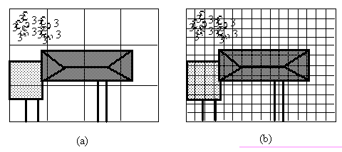
Similar to the spectral case, the surface has to be sampled with certain spatial resolution. The difference is that spatial sampling is mostly systematic, i.e., a complete sampling over an area of interest. The difference in spatial resolution can be seen in Figure 1.5.
Figure 1.5. Sampling the same target with different spatial resolutions.
A scene including a house with garage and driveway is imaged with two different spatial resolutions. For each cell in Figure 1.5a no object occupies an entire cell. Each cell will contain energy from different cover types. Such cells are called mixed pixels, also known as mixels. In Chapter 7, we will introduce some methods that can be used to decompose mixed pixels. Mixed pixels are very difficult to discriminate from each other. Obviously a house cannot be easily recognized at the level of resolution in Figure 1.5a, but it may be possible in Figure 1.5b. As spatial resolution becomes finer, more details about objects in a scene become available. In general it is true that with finer spatial resolutions objects can be better discriminated with human eyes. With computers, however, it may be harder to recognize objects imaged with finer spatial resolutions. This is because finer spatial resolutions increase the image size for a computer to handle. More importantly, for many computer analysis algorithms, they cause the effect of "seeing the tree but not the forest." Computer techniqes are far poorer than human brain in generalization from fine details.
Temporal sampling can be regarded similar to spectral sampling. For example, temporal sampling means how frequently we are imaging an area of interest. Are we going to use contiguous systematic sampling as in movie making or selective sampling as in most photographic actions? To decide the temporal sampling scheme, the dynamic characteristics of the target under study have to be considered. For instance, if the study subject is to discriminate crop species, the phenological calendar of each crop type should be considered for when to collect remotely sensed data in order to best characterize each different crop species. The data could be selected from the entire growing season between late April to early October for mid and high latitudes in northern hemisphere. If the subject is flood monitoring, the temporal sampling frequency should be high during the flood period because floods usually last only a few hours to a few days.
Radiometric resolution can be understood in a similar manner as with spatial resolution. This is a concept well illustrated in a number of digital image processing books (e.g., Gonzalez and Wintz, 1987; Pratt, 1991). It is associated with the level of quantization of an image which is in turn related to how to use the minimum amount of data storage to represent the maximum amount of information. This is often a concern in data compression. Although we will explain the concept of radiometric resolution in Chapter 5, we will only touch the topic of data compression in Chapter 7 from an information extraction point of view.