3.5 Microwave Remote Sensing
Radar represents "radio detection and ranging". As we mentioned before it is an active sensing system. It uses its own energy source - microwave energy. A radar system transmits pulses in the direction of interest and records the strength and origin of "echos" or reflection received from objects within the system's field of view.
Radar systems may or may not produce images
None imaging ï Doppler radar -used to measure vehicle speeds.
ï Plan Position Indicator (PPI) - used to observe weather systems or air traffic}Ground Based Imaging radar ï Side-looking airborne radar (SLAR) }Air Based
SLAR systems produce continuous strips of imagery depicting very large ground areas located adjacent to the aircraft flight line. Since cloud system is transparent to microwave region, a SLAR has been used to map tropical areas such as SLAR Amazon River Basin. Started in 1971 and ended in 1976, the project RADAM (Radar of the Amazon) was the largest radar mapping project ever undertaken. In this project, the Amazon area was mapped for the first time. In such remote and cloud covered areas of the world, radar system is a prime source of information for mineral exploration, forest and range inventory, water supplies and transportation management and site suitability assessment.Radar imagery is currently neither as available nor as well understood as other image products. An increasing amount of research is being conducted on interaction mechanism between energy and surface targets, such as forest canopy, and on the combination of radar image with other image products.
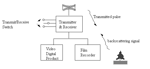
SLAR system organization and operation are shown in Figure 3.22.
Figure 3.22. A RADAR system components and organization
Spatial Resolution of SLAR systems
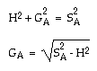
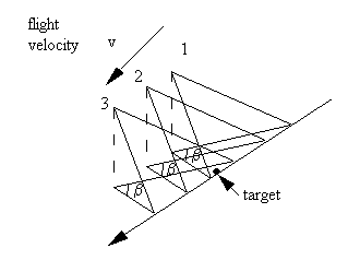
The ground resolution of SLAR system is determined by two independent sensing parameters: pulse length and antenna beam width (Figure 3.23).
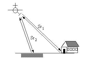
The time period can be measured from a transmitted signal travelling through the air reaching the target and being scattered back to the antenna. We then can determine the distance or the 'slant range' between the antenna and the target.
where
- Sr: the slant range.
- c: the speed of light.
- t: time period for a returned transmitted pulse.
Figure 3.23
From Figure 3.23, it can be seen that SLAR depends on the time it takes for a transmitted pulse being scattered back to the antenna to determine the position of a target.
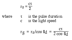
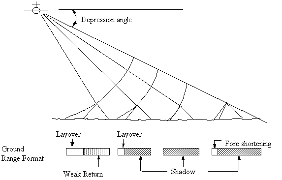
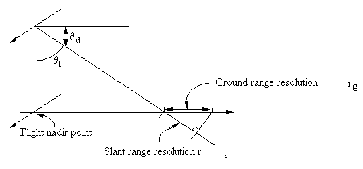
In the across track direction, there is a spatial resolution which is determined by the duration of a pulse and the depression angle (Figure 3.24). This resolution is called ground range resolution. (rg)
Figure 3.24. The across track spatial resolution
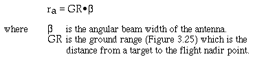
The along track distinguishing ability of a SLAR system is called azimuth resolution ra:
Figure 3.25. The sidelobes of a RADAR signal
It is obvious that in order to minimize rg, one needs to reduce t. For the case of ra, the optimal situation is determined by b which is a function of wavelength l and antenna length a
can be the actual physical length of an antenna or a synthetic one.
Those systems whose beam width is controlled by the physical antenna length are called brute force or real aperture radar.
For a real aperture radar, the physical antenna length must be considerably longer than the wavelength in order to achieve higher azimuth resolution. Obviously, it has a limit at which the dimension of the antenna is not realistic to be put onboard an aircraft or a satellite.
This limiation is overcome in synthetic aperture radar (SAR) systems. Such systems use a short physical antenna, but through modified data recording and processing techniques, they synthesize the effect of a very long antenna. This is achieved by making the use of Doppler effect (Figure 3.26).
Figure 3.26. The use of Doppler Effect
Synthetic aperture radar records the frequency differences of backscattering signal at different aircraft position during the time period when the target is illuminated by the transmitted energy.
SAR records both amplitude and frequency of backscattering signals of objects throughout the time period in which they are within the beam of moving antenna. These signals are recorded on tapes or on films. This leads to two types of data processing.
One of the problem associated with processing radar signals from tapes is that the signal is contaminated by random noise. When displayed on a video monitor, the radar image tends to have a noisy or speckled appearance. Later in the digital analysis section, we will discussed the speckle reduction strategies.
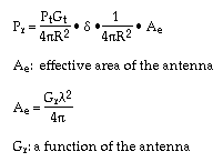
What we actually measure is the backscattered energy Pr in Watts.
Antenna transmitts Pt watts
At a distance R the power is
Power received at Antenna:
If the same antenna is used for both transmitting and receiving, then
All parameters in this formula except "d" is determined by the system. Only d is parameter related to the ground target. Unfortunately, d is a poorly understood parameter which largely limits its use in remote sensing.
We know d is related not only to system variables including wavelength, polarization, azimuth, landscape orientation, and depression angle, but also to landscape parameters including surface roughness, soil moisture, vegetation cover, and micro topography.
ï moisture influences the dielectric constant of the target which in turn could significantly change the backscattering pattern of the signal. Moisture also stops the microwave penetrating capability.
ï Roughness - the standard deviation S(h) of the heights of individual facets.
In the field, we use an array of sticks arranged paralell to each other with a constant distance interval to measure the surface roughness.
A common definition of a rough surface is one whose S(h) exceeds one eighth of the wavelength divided by the cosine of the incidence angle
As we illustrated in the spectral reflectance section, a smooth surface will tend to reflect all the energy input at an angle equal to the incidence angle, while a rough surface tends to scatter the incoming energy more or less at all direction.
Microwave energy can be transmitted and received by the antenna at a selected orientation of the electromagnetic field. The orientation or polarization of the EM field is labelled as Horizontal (H) and Vertical (V) direction. The antenna can transmit using either polarization. This EM energy makes it posible for a radar system to operate in any of the four models transmit H and recieve H, transmit H receive V, transmit V recieve H, and transmit V receive V. By operating at different modes, the polarizing characteristics of ground target can be obtained.
It tends to collect
reflected signal at its foreground and returns the signal to the antenna.
Microwave Bands
Band
Wavelength 1
Ka
0.75 - 1.1 cm
40 - 26.5 GHz
K
1.1 - 1.67 cm
26.5 - 18 GHz
Ku
1.67 - 2.4cm
18 - 12.5 GHz
X
2.4 - 3.75cm
12.5 - 8GHz
C
3.75 - 7.5cm
8 - 4GHz
S
7.5 - 15cm
4 - 2GHz
L
15 - 30cm
2 - 1GHz
P
30 - 100cm
1 - 300 MHz
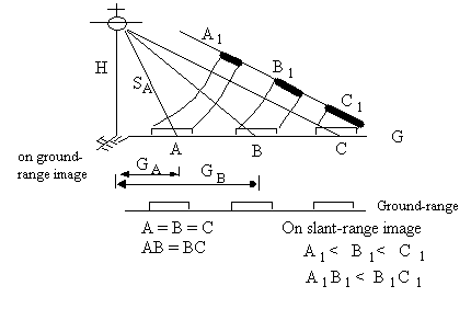
Radar uses two types of image recording systems, a slant-range image recording system and a ground-range image recording system.
In slant-range recording system, the spacing of targets is proportional to the time interval between returning signals from adjacent targets.
In ground-range image recording system, the spacing is corrected to be approximately proportional to the horizontal ground distance between ground targets.
If the terrain is flat, we can convert the slant-range spacing SR to Ground range GR
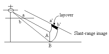
Relief displacement is different on the photographs from SLAR images.
- Seasat launched in1978, duration 98 days
- Frequency L band
- Swath width 100 km centered at 20¡ from nadir
- Polarization HH
- Ground Resolution 25 m x 25 m
- Shuttle Imaging Radar, SIR-A, SIR-B, SIR-C
- The Euraopean Space Agency has lauched a satellite in 1991: ERS - 1, with a C band SAR sensor.
- In 1992, the Japanese JERS -1 satellite was launched with a L band radar mounted. The L band radar has a higher penetration capability than the C band SAR.
- Radarsat
- Scheduled to be launched in mid 1995, Radarsat will contain a SAR system which is very flexible in terms of configurations of incidence angle, resolution, number of looks and swath width.
Radarsat
Frequency
C band 5.3 GHz
Altitude
792 Km
Repeat Cycle
16 days
Radarsat Subcycle
3 day
Period
100.7 min (14 cycles per day)
Equatorial crossing
6:00 A.M.
Platform
Satellite OrbitsCampbell's Book p. 118-129


.gif)