ESPM 172
ESPM 172
Laboratory #6 Vertical Measurements and Assignment #3 Photo-Orientation
This work is due on April 10 or 11 worth 20 points.
Objective:
To become familiar with the methods for making vertical measurements on aerial photographs.
fl = 6 inches Photo scale = 1:12,000
A. Displacement Method (Photo # 3)
1. Using your millimeter ruler (to the nearest 0.1 mm), use the displacement method to estimate the heights of Barrows Hall, Stanley Hall, Sather Tower and the power tower on the top-left corner of the photo. What is the problem with using this method to measure the height of the towers?
B. Estimating heights using two photos
Set the photos up for stereo viewing making sure the flight lines are colinear. Assume that the pp's on both photos are at the same elevation.
1. Preliminary height information from field survey or map reading
a) Elevation of the bottom of the Sather Tower is 320'
b) Elevation of the base of Barrows Hall is 285'2. Use your ruler to estimate the difference in absolute parallax (dP) and total height of :
a) The Tower dP = ________ h = ___________
b) Barrows Hall dP = _________ h = ___________
c) Stanley Hall dP = _________ h = ___________3. Estimate the difference in absolute parallax (dP) and the total height of both objects using the pocket stereoscope and the Sokkisha parallax bar.
a) The Tower dP = __________ h = ___________
b) Barrows Hall dP = __________ h = ___________
c) Stanley Hall dP = _________ h = ___________C. Questions (briefly explain your answers)
1. Rank the height estimation methods according to their accuracy?
2. Rank the height estimation methods according to their precision?
Assignment # 3
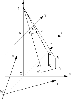
The following diagram shows three coordinate systems:
xoy photo-coordinate system
XOY photo-coordinate system projected to the ground surface plane at sea level
UWV a ground coordinate system or map coordinate systemFrom the photo, coordinate of two points have been measured with their elevation measured from vertical measurement using a parallax bar from a stereopair. These measurements are:
a xa = 0.9447", ya = 0.5455", elevation = 500'
b xb = 2.0784", yb = 1.2", elevation = 1000'Their corresponding coordinates in the map coordinate system are also known:
A) UA = 2000', VA = 1500'
B) UB = 3000', VB = 1500'Given that the focal length of the photograph is 6" and the flight height is 6000', find out
1. The point scales for points a and b
2. The angle formed by line segment ab with oy
3. XA and YA, XB and YB
4. The angle formed by line segment A'B' and OY
5. The angle between A'B' and WV
6. The angle between OY and WV
7. The translation between W and O
8. The transformation equations between UWV and XOY coordinate systems. Use the determined transformation equations to find out UC and VC if the photo coordinates of c is measured as xc = 1.25", yc = 2.165" and elevation = 1200'.