Note about privacy: SODMAP Mobile does not collect, store, or share any user information or data
The app automatically updates the reference database when new points are added to the SODmap. Stream samples are not included in SODmap mobile.

The default setting for the map is the satellite view which is optimized for clear viewing of the symbols and icons. By selecting the “settings” tab, however, it is possible to change to a hybrid map (e.g. a satellite map with major streets and localities superimposed), or to the standard map.
When viewing SODmap at a regional scale level, individual points will not be visible. Instead, white numbers will indicate major clusters of trees sampled in each area. The number itself represents the actual number of samples and it is positioned approximately in the central point of the cluster of contiguous sampled trees. As you enlarge the view, major clusters of sampled trees will split into smaller clusters; again the numbers will be positioned in the center of the sample area each number represents.
When the scale allows for it, the actual individual trees will be visible as colored drop pins. Red pins indicate SOD positive trees, while green indicates trees that were sampled but were negative for Phytophthora ramorum, aka the SOD pathogen, when tested in the laboratory. By touching the drop pin, the species of the tree sampled will appear in a pop up box.
Additionally, the dialog box also indicates whether the tree was sampled before or after the 2007-2009 drought. The map allows you to determine the number, location, and infection status of trees while in the field. The blue pin indicates the position of the user, making it easy to locate any trees of interest present on the SODmap. It is also possible to use SODmap to determine Longitude and Latitude of the user, by selecting the risk tab.
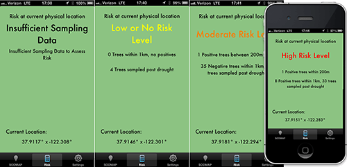
A second function of the SODmap mobile, is to estimate risk of oak infection at the physical location of the user. Risk is based on proximity of infected trees to the user. The risk level at the location of the user can be determined by selecting the risk tab.
The risk warning also reports the number of trees sampled within 1000m and when the positive trees were sampled. As the number of trees increases, the confidence in the risk rating increases.
For warmer inland areas, confidence is higher if the positive trees were sampled post-drought, as outbreaks may disappear or shift during a drought in locations that are less favorable for pathogen establishment.
At times, especially if reception is poor, the app will show the risk rating of the previous location. Ensure the lat. and long. have changed since the last risk assessment: that indicates the risk rating is current.