4.2 Factors Affecting Image Geometry
In remote sensing there are three major forms of imaging geometry as shown in Figure 4.5:

Figure 4.5 The major types of imaging geometry
The first one is central perspective. It is the simplist because the entire image frame is defined by the same set of geometrical parameters. In the second imaging geometry, each pixel has its own central perspective. This is the most complicated because each pixel has to be corrected separately if there exists geometrical distortion. The third one shows that each line of an image has a central perspective.
The platform status which can be represented by six parameters all affect the image geometry.
(X, Y, Z, y, l, r)
In addition, the following factors affect the image geometry.
- airborne platform
- earth rotation - affects satellite
- continental drift
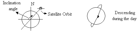
Most remote sensing satellites for earth resources studies, such as the Landsat series and the SPOT, use Sun synchronous polar orbit around the earth (Figure 4.6) so that they overpass the same area on the earth at approximately the same local time. Most of the earth's surface can be covered by these satellites.
Figure 4.6. Sun synchronous polar orbit for Earth resources satellites
The effects of roll, pitch and yaw along the direction of satellite orbit or the airplane flight track can be illustrated by using Figure 4.7.
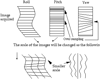
Figure 4.7. The effects of roll, pitch and yaw on image geometry