The Toxic Tides map series shows the risk of flood exposure at hazardous facilities under a high greenhouse gas emission scenario (RCP8.5) in California in the years 2050 and 2100. Facilities included in these maps are those located in counties with low-lying land. A facility is considered at risk of flooding if a quarter of its elevation (25th percentile) falls below the water level. Flood risk estimates are averages of multiple simulations of future sea levels.
The Drinking Water Tool is an online resource for information about drinking water quality and access throughout California for community water systems and domestic well areas.
Read the Water Equity Science Shop’s white paper on the Drinking Water Tool by Clare Pace, Carolina Balazs, Lara Cushing, Rachel Morello-Frosch.
Recording of Drinking Water Tool Launch Webinar CWC Press release on 2/12/2020. Watsonville’s KSBW-8 report on the Drinking Water Tool on 2/12/2020.
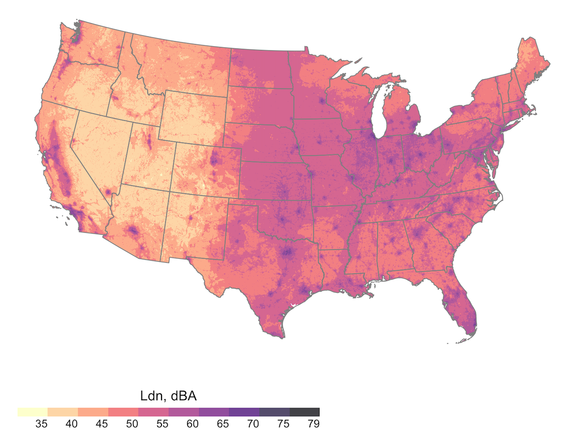
The Noise Pollution interactive map displays census tract level estimates of noise, categorized as below, slightly exceeding, and exceeding the U.S. EPA day-night average sound level (Ldn) limit of <55 decibels (dB). Points (census tract centroids) display values in the small-scale map and census tract boundaries appear when the user zooms in to a specific city. Available on the large-scale (zoomed in) map, users can click a specific census tract and see which noise category the tract falls into: (1) Ldn: low = <55 dB; medium = 55-58 dB; and high = 58+ dB; and (2) Median nighttime noise: low = < 40 dB; medium = 40-43 dB; and high = 43+ dB.
Click here and on the map for more information about the noise data.
For more information and studies related to this data, see Casey et al, 2017 and 500 Cities Project.
California Climate Investments is a statewide initiative that invests cap-and-trade dollars in projects throughout the state. You can track those projects here.
CalEnviroScreen is an online tool developed by Cal-EPA’s Office of Environmental Health Hazard Assessment to map cumulative impacts of environmental and social stressors in communities across the California. The tool guides regulatory and other actions.

Grist is non-profit hard hitting environmental journalism at its best. As an independent media organization, Grist tells stories of climate solutions and a just future.

Environmental Health News is dedicated to driving science into public discussion and policy on environmental health issues, including climate change.