
As firefighters emerge from another record wildfire season in the Western United States, University of California, Berkeley, scientists say it’s time to give them a 21st century tool: a fire-spotting satellite.
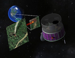
An artist’s concept of the FUEGO satellite, which would snap digital photos of the Western U.S. every few seconds in search of hot spots that could be newly ignited fires. Image by R. E. Lafever, Lawrence Berkeley National Laboratory.
Such a satellite could view the Western states almost continuously, snapping pictures of the ground every few seconds in search of hot spots that could be newly ignited wildfires. Firefighting resources could then be directed to these spots in hopes of preventing the fires from growing out of control and threatening lives and property.
The UC Berkeley scientists have designed such a satellite using state-of-the-art sensors, written analysis software to minimize false alarms, and even given it a name — the Fire Urgency Estimator in Geosynchronous Orbit (FUEGO). They’re hopeful it can be built for several hundred million dollars, either by government or private entities.
“If we had information on the location of fires when they were smaller, then we could take appropriate actions quicker and more easily, including preparing for evacuation,” said fire expert Scott Stephens, a UC Berkeley associate professor of environmental science, policy and management. “Wildfires would be smaller in scale if you could detect them before they got too big, like less than an acre.”
Stephens, physicist Carl Pennypacker, remote sensing expert Maggi Kelly and their colleagues describe the satellite in an article published online Oct. 17 by the journal Remote Sensing.
“With a satellite like this, we will have a good chance of seeing something from orbit before it becomes an Oakland fire,” said Pennypacker, a research associate at UC Berkeley’s Space Sciences Laboratory and scientist at Lawrence Berkeley National Laboratory, referring to the devastating 1991 fire that destroyed more than 3,000 homes in Berkeley and Oakland. “It could pay for itself in one firefighting season.”
With global warming, Stephens said, wildfires are expected to become more frequent and more extensive. This year alone, California’s firefighting arm, CAL FIRE, has responded to over 6,000 wildfires, 1,600 more than average, according to tweets by the department’s information officer Daniel Berlant. Wildfire-prone areas stretching from Spain to Russia could also benefit from their own dedicated satellites.
-By Robert Sanders, UC Berkeley Media Relations
Read the full article.