
Despite concerns about conflict and calls for their removal, coyotes have found ways to persist across the sprawling metropolis of Los Angeles.
If you stop and look, these resilient and elusive creatures can be found everywhere—from the region’s concrete canyons and sun-drenched hillsides to bustling neighborhoods and quiet suburban backyards. Their presence in these locales is not just a testament to their adaptability, but also raises the question: how did they get there.
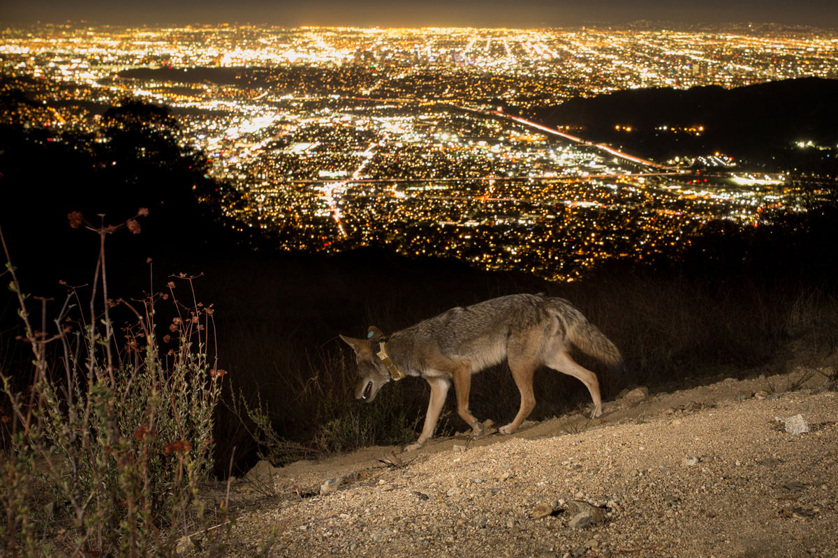
Photo by Johanna Turner.
A new study of coyote movement patterns published today in Ecology Letters challenges previous research that suggests ecological landscape features—like the availability of water, vegetation, and habitat—are the best predictors of coyote movement and behavior. Led by Environmental Science, Policy, and Management (ESPM) alum Christine Wilkinson, now a research associate at the California Academy of Sciences, the study finds that factoring in an area’s wealth, pollution, human population density, and other societal data points with information about regional landscapes and linear infrastructure—such as roads and railways—results in a more accurate prediction of where and how far a coyote will likely roam.
“We know that human activities and choices can really influence habitats and wildlife behavior,” said Wilkinson, PhD ’21 ESPM, a recent postdoctoral researcher in the lab of Assistant Professor Christopher Schell. “But what we don’t really know is how the ways that people use the land interact with societal and ecological factors to influence wildlife movement.”
Collaring coyotes, collecting data
A conservation scientist and carnivore ecologist, Wilkinson studied resource conflict and coexistence between humans and carnivores as a PhD student in the lab of Professors Maggi Kelly and Justin Brashares. As part of her research, Wilkinson leveraged participatory mapping sessions to gather data from community members near Lake Nakuru National Park in Kenya in hopes of better understanding what factors might motivate spotted hyenas to cross fences intended to keep them out.
The methodology she piloted in Kenya served as the basis for this study of coyotes, which Wilkinson hoped would challenge the notion that urban areas have little to offer wildlife. “Urban areas are actually petri dishes where many social-ecological components come together in an acute way,” she said. “Despite that, they’ve been grayed out on many conservation maps even though we know that they are home to important wildlife habitat.”
To better understand how coyotes actually moved throughout the region, Wilkinson partnered with co-author Niamh Quinn, the human-wildlife interactions advisor for the University of California Agricultural and Natural Resources South Coast Research and Extension Center, to collect accurate data about coyote movement. “I’ve heard a lot from people on the ground that it’s never been like this,” she said. “Seeing a coyote in an urban environment was very rare 15 to 20 years ago, whereas seeing one now is very common.”
Over the past decade, Quinn has coordinated efforts by experienced trappers to collar dozens of coyotes for research. “There's only one true thing about a coyote, and that is that they will make a fool of you,” she added. “You really have to know the coyote before you put the trap down, and because you’re trapping in urban areas a lot of the time, we have to be careful that we don’t catch anything else.”
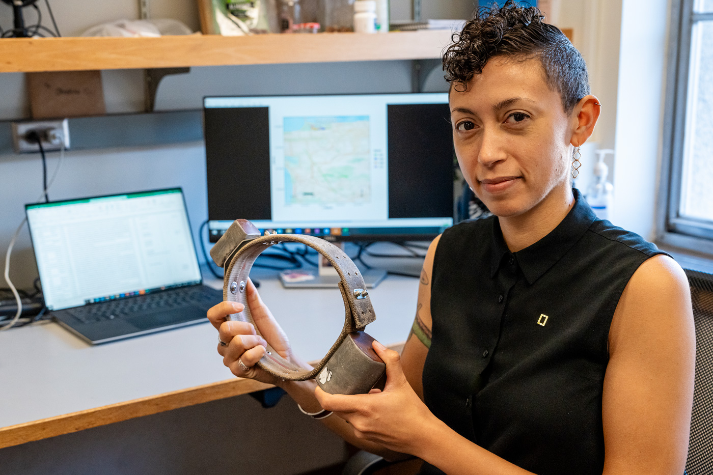
Wilkinson holds a GPS collar similar to the ones used in the study. California Academy of Sciences photo by Gayle Laird.
For this study, 20 coyotes were trapped by the Los Angeles County Agricultural Commissioner’s office and outfitted with solar-powered GPS collars that reported their location at intervals ranging from 15 minutes to two hours. Information about a coyote’s habitat selection was calculated by analyzing GPS data and comparing that to the coyote's movements in relation to the landscape. That information was combined with county-level geospatial information, census data, and metrics reported by CalEnviroScreen: a comprehensive statewide environmental health screening tool developed by the California Environmental Protection Agency.
“Our prior work focused heavily on biodiversity patterns in relation to legacies of residential segregation, implicating redlining as a potential contributor to variable species counts across cities,” said Schell, the study’s senior author. “Our current study offers evidence of how coyotes and other wildlife are navigating cities by making far more complicated and integrated decisions based on the entire tapestry of urban conditions surrounding them.”
Unraveling urban complexity
Historically, animal movement models have often focused on ecological features and usually predict that coyotes prefer areas with more vegetation or proximity to water. Unfortunately, these models don’t fully explain coyote behavior in complex urban environments. Wilkinson notes that only a few coyote studies have considered the impact of roads or railways on behavior, and emphasizes the need to further explore how other societal elements—like pollution—may “leave a signature” on animal movement.
By integrating information about a region’s ecological and linear infrastructure with societal metrics, the authors were able to generate a more accurate prediction of coyote movement than models that only contained one or the other. Human population density and development intensity, a measure of an area’s building density and percentage of human-built surfaces that don't absorb water, were found to be the strongest influences on coyote movement and habitat selection, according to their findings, while the distance to cemeteries and golf courses—where coyote sightings can be common—emerged as the weakest.
Overall, coyotes living in the region’s more anthropogenically burdened areas (which are characterized by higher pollution and development intensity) display different movement patterns than those in less burdened areas. Specifically, coyotes in burdened areas have larger home ranges, longer step lengths, and higher values of mean daily displacement, which is a measure of exploration. “They might need to go further to navigate scattered resources and respond to disturbances, which might also result in higher energetic costs,” said Wilkinson. “Taken together, it’s safe to say that urban complexity and human disturbances can significantly shape coyote behavior.”
Neighborhood wealth proved a surprising predictor of coyote behavior, as the coyotes tracked in the study tended to avoid higher-income areas. Wilkinson said the finding runs contrary to the idea of the luxury effect, where wealthier areas tend to have higher levels of biodiversity due to their high-quality habitat and natural resources. When coyotes moved into those areas, the authors found that they moved more slowly than coyotes who live in poorer or more densely developed areas.
“Wealthier areas tend to have a more separationist and negative view toward coyotes,” said Wilkinson, suggesting a possible explanation for the change in behavior. “There are a lot of people that take out permits to remove coyotes, which doesn’t happen in lower-income areas as it's very expensive to hire a trapper.”
The study also revealed the different ways that roads, railways, and flood channels act as movement corridors for coyotes rather than just barriers. The effects varied depending on the type of infrastructure and where it was found. For instance, coyotes generally had higher step lengths in areas with higher road density, while coyotes in lower-income areas were more frequently found near railways than their counterparts in less-burdened areas.
Bridging human and wildlife wellbeing
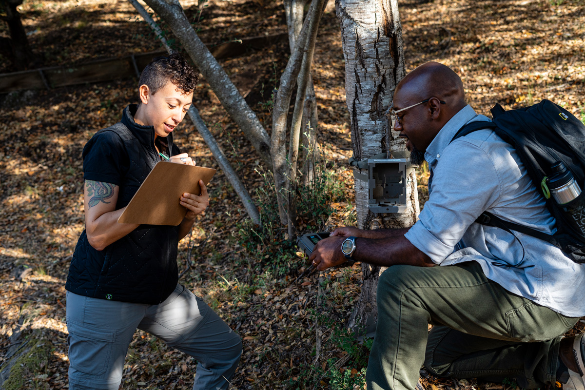
Wilkinson and Schell in the field. California Academy of Sciences photo by Gayle Laird.
Schell, an ecologist who studies how urban attributes and social inequities affect wildlife and people in cities, said the study’s findings challenge traditional approaches to urban planning and wildlife conservation, acknowledging that human and wildlife wellbeing are inherently linked.
“Our work joins the chorus of a growing literature that spotlights how human-driven inequities affect environmental, wildlife, and human health, a core principle of the Schell Lab’s research mission,” he said. “Looking forward, as our human footprint continues to expand globally, the ultimate success of wildlife will rest in our ability to establish healthy, equitable, and functioning cities."
Wilkinson hopes the study can provide a holistic view of the influences of social-ecological features on wildlife connectivity in Los Angeles, as much of the data the authors used had historically been siloed across different fields. She hopes that urban planners will continue to center intracity connectivity for wildlife in their work, aiming to create designs that are thoughtfully tailored to the needs of both biodiversity and human well-being.
“People are exposed to the very same pollutants and burdens that these coyotes are exposed to,” she said. “Understanding those linkages between our wellbeing can really give us paths to consider when making big decisions for urban design and redesign.”
Additional co-authors include Curtis Eng, associate professor of zoo, exotic, and wildlife medicine at the Western University of Health Sciences College of Veterinary Medicine. Funding for the project was provided by the Los Angeles County Productivity Investment Fund and by Schmidt Science Fellows, in partnership with the Rhodes Trust.
Read More